Top 10 Most Bizarre Types of Clouds
The fact that clouds can form a huge variety of shapes makes them a fascinating part of nature. It doesn't take an expert to identify these unique cloud formations.
These are clouds you aren't likely to see every day. Ranging from wave-like clouds to disproportionately long, thin shapes, this list presents the most bizarre types of clouds, most of which you have probably never seen in your lifetime.
-
Morning Glory Cloud
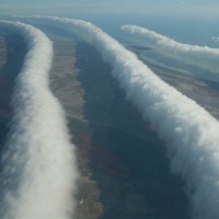
This cloud is one of the rarest yet most bizarre types of clouds you could possibly encounter once in a lifetime, although it is more common in Australia. These are a type of roll cloud that come in waves and often take the appearance of long lines, as seen in the image. They can span up to hundreds of miles.
It's still unclear how these types of clouds form, but it is speculated that they appear when winds blow and collide from the west and east. If there's enough moisture at the gulf, then these clouds will form. However, these clouds are able to form in multiple ways that cannot be fully explained.
Bizarrely beautiful. Cloud surfing, anyone?
-
Horseshoe Cloud
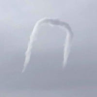
Taking the shape of the letter U, this is not the average cloud you see every day, and this very bizarre cloud is no exception. This is a very rare type of cloud that only occurs when air gets caught in a spinning vortex. Like the diverse lenticular cloud, this cloud is mistaken as a sign of aliens, especially when seen at first glance.
What makes this cloud so rare is that it deforms and fades at a fast rate, and it is typically small in size, thus making it harder to spot.
-
Noctilucent Cloud
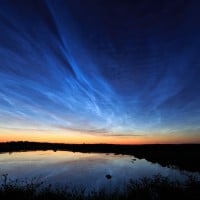
Sharing similar traits to polar stratospheric clouds, these types of clouds hover at the highest altitudes compared to all types of clouds, up to a whopping 250,000+ feet high, and are composed of ice crystals. They are mostly seen in the summer and spring months when the sun is below the horizon. They form under very cold temperatures and dusty conditions, possibly from space.
-
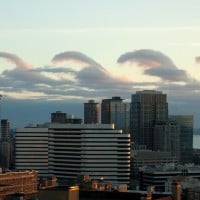
Lenticular Cloud
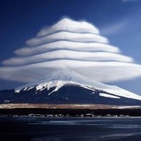
Often taking the form of a saucer shape, these wide, tornado-looking clouds are commonly mistaken as UFO sightings. They come in various distinctive bizarre shapes such as hats (as seen in the image), lenses, arcs, and funnels, and even take on the appearance of other types of clouds.
Lenticular clouds are more common near mountains and form when moist air flows over the slopes of the mountain, creating waves. If these conditions are right, these bizarre clouds form.
Fascinating. I would have thought I had seen most types of clouds, but that is clearly not the case. Thank you for such a detailed and thorough list. This formation is really cool.
-
Supercell Storm Cloud
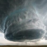
Supercell storm clouds are often associated with anvil clouds. You may have seen one. Although they are uncommon, they are a sign of severe weather, including tornadoes, and are harbingers of one of the most ravaging thunderstorms. These types of clouds can last for hours.
I definitely don't want to run into that! Gives me chills up my spine.
They look pretty amazing, yet harmful.
-
Mammatus Cloud
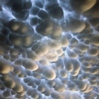
While mammatus clouds come in distinct formations, these types of clouds typically look smoothly round-shaped, like chunks of marshmallows floating in the sky. They are commonly associated with cumulonimbus clouds, anvil clouds, and other types of clouds on occasion. They are often formed when cold air descends.
If these types of clouds come along with cumulonimbus clouds, this is a sure sign of a thunderstorm and other severe weather. There are a handful of theories about how these bizarre types of clouds form.
Kind of looks like flying popcorn.
-
Kelvin-Helmholtz Wave Cloud
Also known as billow clouds. If you think you haven't spotted this cloud yet, your eyes might consider it fake due to its unrealistic shape. They take the appearance of crashing waves. Another name for them is tsunami clouds. This phenomenon doesn't only occur in the clouds but also in oceans and even on other planets.
They may seem rare, but they can be a bit more common if you observe enough, as they typically do not last long. If you want to spot this cloud, make sure it's a windy day.
-
Punch Hole Cloud
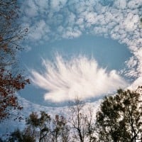
Also called a hole punch cloud, fallstreak cloud, or cavum. They have several nicknames, but let's stick to the punch hole cloud. This type of cloud forms large gaps that look as if a hole has been punched open (hence the name), typically taking the shape of a circle or oval. They are often seen in altocumulus or cirrocumulus clouds.
These holes form when the temperature goes below the freezing point, and the supercooled droplets in the clouds freeze into ice crystals, thus making these gaps form outward.
-
Polar Stratospheric Cloud
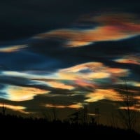
Also called nacreous clouds, these clouds typically hover as high as 80,000 feet and consist of ice crystals. Their most distinctive feature is the vibrant colors that shine bright on the clouds, especially at sunset and sunrise when sunlight is the strongest.
Due to their uncommon appearances, they are only formed at very cold temperatures, typically near the north and south polar regions. Despite their vibrant appearance, these clouds pose a danger and destruction to the ozone in the Arctic.
-
Pyrocumulus Cloud
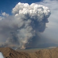
Also known as a flammagenitus cloud, or simply a fire cloud. Seeing this usually humongous mass of smoke and vapor at first sight, you may think a volcano has exploded nearby. Sometimes that may be true, but they are most often caused by very hot air and are associated with wildfires.
Pyrocumulus clouds are also capable of making their own weather systems and can be dangerous as they are a harbinger of violent winds.
-
?
Cumulonimbus Incus Cloud
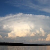
The common thunderclouds. Probably my favorite type of cloud. It's also one of the tallest clouds. Not necessarily rare, but they look incredible from a distance.
-
?
Undulatus Asperatus Cloud
-
Cirrus Uncinus Cloud
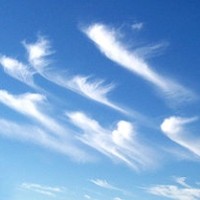
Part of the cirrus cloud type, these clouds take the strange yet breathtaking shape of wispy hooks or tails. They drift fairly high and form at low temperatures. This cloud type's name, "uncinus," means "hook," which describes the distinctive shape of the cloud.
Reminds me of those clouds from Up.
-
Pileus Cloud
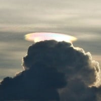
Also known as cap clouds or scarf clouds, this is a type of lenticular cloud composed of ice crystals that typically sit above thunderstorms when there's significant moisture above a heavy cumulonimbus cloud. Picture it like a hat or a halo sitting on top of the cloud.
Pileus clouds are formed when air rises rapidly. At times they can be hard to see, as they fade quite quickly. Occasionally, iridescent colors can be seen on the pileus cloud due to sunlight shining on it. If you see this type of cloud, it is a sure sign that severe weather is bound to happen.
-
Cirrocumulus Cloud